Trail On foot Homberg (Ohm) - GeoTour Felsenmeer - Photo

Tous les sentiers balisés d’Europe GUIDE+

© OpenStreetMap contributors
Length
Length
6.3 km
Max alt
Max alt
359 m
Uphill gradient
Uphill gradient
128 m
Km-Effort
Km-Effort  
8 km
Min alt
Min alt
279 m
Downhill gradient
Downhill gradient
128 m
Boucle
Boucle
Yes
Signpost
Signpost
Creation date :
2022-02-11 16:21:03.406
Updated on :
2022-02-11 16:21:03.406

(0 Reviews)

On foot
On foot
1h49
Difficulty : Easy

Scan this QR Code to open this trail in the SityTrail application

FREE GPS app for hiking

Logo SityTrail SityTrail

IGN / Geographical institutes

Download SityTrail from the App Store Download SityTrail from Google Play

Logo SityTrail SityTrail World

The world is yours!

Download SityTrail from the App Store Download SityTrail from Google Play Download SityTrail on Huawei AppGallery

About

Trail On foot of 6.3 km to be discovered at Hesse, Vogelsbergkreis, Homberg (Ohm). This trail is proposed by SityTrail - itinéraires balisés pédestres.

Description

Trail created by Stadt Homberg/Ohm.

Symbol: Bild eines Vulkans, darüber der Text "GeoTour", darunter der Text "Felsenmeer"

Elevation profile

Photos

Positioning

Country:
Germany
Region :
Hesse
Department/Province :
Vogelsbergkreis
Municipality :
Homberg (Ohm)
Location:
Unknown
Start:(UTM)
500098 ; 5620583 (32U) N.

Trails nearby

Trail On foot Stadtallendorf - Geotour Kreuz & Quer - Photo
On foot
GUIDE+

On foot

Easy
Stadtallendorf, Hesse, Landkreis Marburg-Biedenkopf, Germany
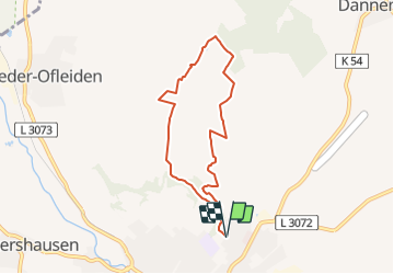
12.3 km | 13.6 km-effort
3h 4min
Yes
Trail On foot Homberg (Ohm) - SchächerbachTour Homberg - Photo
On foot
GUIDE+

On foot

Easy
Homberg (Ohm), Hesse, Vogelsbergkreis, Germany
9 km | 12 km-effort
2h 44min
Yes


Close
My subscriptions